
John Speed's Map of Reading, published in 1610

|
John Speed's Map of Reading, published in 1610 |
|
|
John Speed (1552-1629) was an early mapmaker and historian. He produced plans of many English towns, one of which showed Reading as it was laid out in 1610. Below is the part of the Reading map showing the Abbey area of the town. |
The key on Speed's map interprets the items in the Abbey area as follows:- |
|
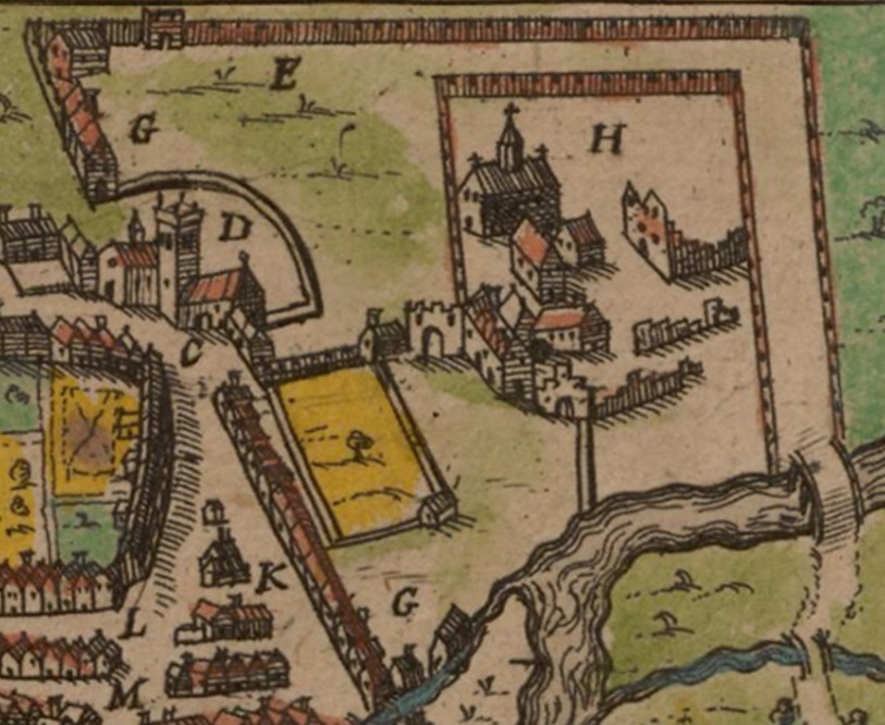 |
C: The Free School D: St Laurence E: Forbury G: The Queen's stables H: The Abbey K: Shoemakers Row L: Fish Street M: Butchers Row *** Speed's maps were of counties, with each one including plans of major towns or drawings of prominent features. The plan of "Redding" is in fact contained in the map of Buckinghamshire. The Berkshire map displays a prominent drawing of Windsor Castle and has no room for town plans. Speed's complete map of Reading can be seen on Wikipedia at Redding . The full set of Speed's maps can be seen on the website of the Cambridge University Digital Library at Speed's maps - click on the Contents tab or Thumbnails tab. The Buckinghamshire map is image 10, the plan of Reading is at top right. Note also the explanation just to the left of the plan of Reading. |